


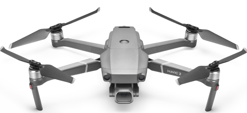
 DJI Mavic 2 Pro Zoom 4K Video 12MP Drone
Introduction
The DJI Mavic 2 Pro/Zoom features omnidirectional Vision Systems and Infrared Sensing Systems. Effortlessly capture complex shots using signature Dul technologies such as Obstacle Sensing and Intelligent Flight Modes like Hyperlapse, Point of Interest, ActiveTrack™ 2.0, TapFly, QuickShots, and
Advanced Pilot Assistance Systems (APAS).
- The Mavic 2 Pro features a fully stabilized 3-axis gimbal with a 1″ CMOS sensor camera (jointly
developed by Dul and Hasselblad) that shoots 4K video, 20-megapixel photos, and supports filters. - The Mavic 2 Zoom features a fully stabilized 3-axis gimbal camera that shoots 4K video, 12-megapixel photos, supports 2x optical zoom, a 24-48 mm lens, and supports filters.
- The Mavic 2 Pro/Zoom uses the latest technology to increase stability and footage quality, reducing the Mavic 2 Zoom angle vibration range to within 0.005° and the Mavic 2 Pro angle vibration range to within ÷0.01°.
- Built into the remote controller is DJI’s long-range transmission technology, OCUSYNC™ 2.0, offering a
maximum transmission range of 5 mi (8 km) and displaying video from the aircraft to Dul GO 4 on your
mobile device at up to 1080p. - The remote controller works at both 2.4 GHz and 5.8 GHz, and it can select the best transmission channel automatically without any latency. The aircraft and camera can easily be controlled using the onboard buttons.
- An onboard LCD screen gives real-time aircraft data information, and the detachable control sticks make the remote controller easier to store. The maximum run time is 2 hours and 15 minutes. The Mavic 2 Pro/Zoom boasts a maximum flight speed of 44.7 mph (72 kph) and a maximum flight time of 31 minutes.
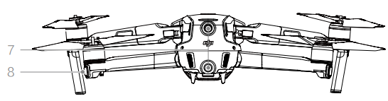
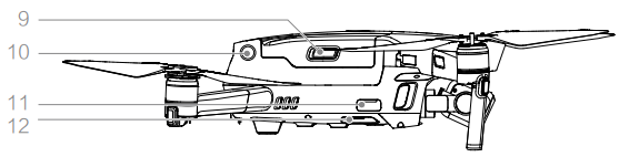
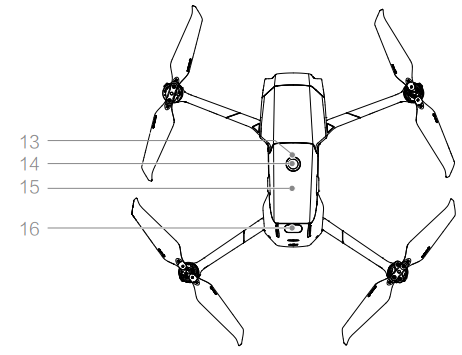
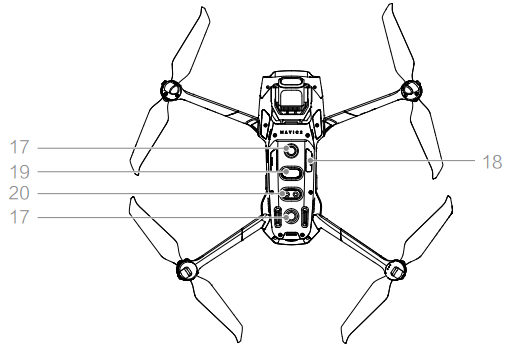
Aircraft Diagram
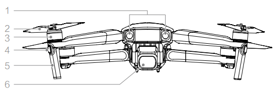
- Forward Vision System
- Propellers
- Motors
- Front LEDs
- Antennas
- Gimbal and Camera

- Backward Vision System
- Aircraft Status Indicator

- Battery Buckles
- Lateral Vision System
- USB-C Port
- Link Button/Linking Status Indicator

- Battery Level LEDs
- Power Button
- Intelligent Flight Battery
- Upward Infrared Sensing System

- Downward Vision System
- microSD Card Slot
- Downward Infrared Sensing System
- Auxiliary Bottom Light
Remote Controller
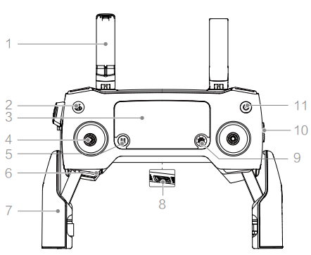
- Antennas
- Relay aircraft control and video wireless signals.
- Return to Home (RTH) Button
- Press and hold the button to initiate RTH.
- LCD Screen
- Displays the aircraft and remote controller system status.
- Removable Control Sticks
- The removable control sticks are easy to store.
- Flight Pause Button
- Press to make the aircraft brake and hover in place.
- Control Sticks Storage Slot
- For storing the control sticks.
- Mobile Device Clamps
- Securely mount your mobile device onto the remote controller.
- Reserve Video-Downlink Port (USB)
- Connect to a mobile device for video downlink via a standard USB cable.
- 5D Button
- Left: Decrease EV value.
- Right: Increase EV value.
- Up: Recenter the imbal/gimbal downward.
- Down: Recenter the gimbal/gimbal downward.
- Press down: Bring up the DJI GO 4 Intelligent Flight menu.
- Flight Mode Switch
- Switch between S-mode, P-mode, and T-mode.
- Power Button
- Press once to check the current battery level.
- Press once, then again, and hold to turn on/off the remote controller.

- C1 Button (Customizable)
- The default configuration is center focus.
- Adjust the configuration in DJI GO 4 based on your preferences.
- Gimbal Dial
- Controls the camera’s tilt.
- Video-Downlink/Power Port (micro USB)
- Connect to a mobile device for video linking via the RC cable.
- Connect to the AC Power Adapter to charge the remote controller battery.
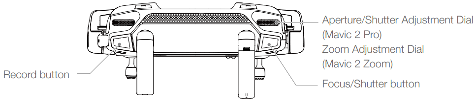
- Record Button
- Press to start recording video. Press again to stop recording.
- Focus/Shutter Button
- Press halfway to autofocus.
- Press once to take photos according to the mode selected in the DJI GO 4.
- Aperture/Shutter Adjustment Dial (Mavic 2 Pro)
- Zoom Adjustment Dial (Mavic 2 Zoom): Turn to adjust the zoom of the Mavic 2 Zoom camera.
- C2 Button (Customizable)
- The default configuration is for playback
- . Adjust the configuration in DJI GO 4 based on your preferences.
Activation
The Mavic 2 Pro/Zoom requires activation before first-time use. Follow the onscreen guide to activate the Mavic 2 Pro/Zoom using DJI GO 4.
Preparing the Aircraft
All aircraft arms are folded before the aircraft is packaged at the factory. Follow the steps below to unfold the aircraft.
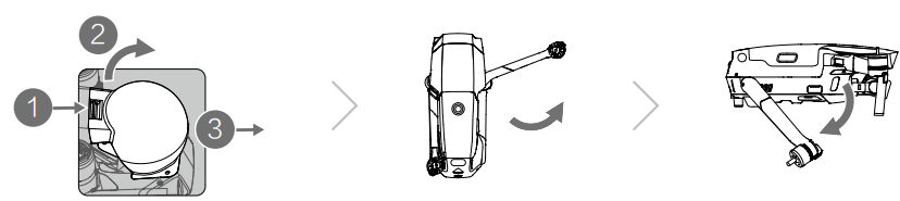
- Remove the gimbal cover from the camera.
- Unfold the front arms, and then unfold the rear arms.
- Attach the gimbal cover when not in use.
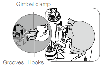
- Hold the gimbal in place and insert the gimbal clamp between the aircraft and the gimbal.
- The buckle will click when it is securely attached.

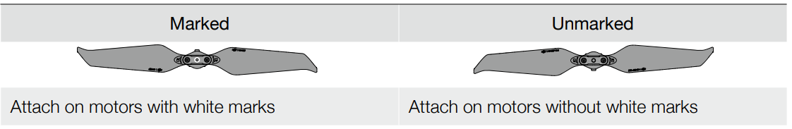
- Attaching the propellers.
- Attach the propellers marked white to the motors with white marks.
- Press the propeller down onto the motors and turn until it is secure. A
- ttach the other propellers to the unmarked motors. Unfold all the propeller blades.

Intelligent Flight Batteries
All Intelligent Flight Batteries are in Hibernation mode before shipment to ensure safety. Use the
provided an AC power adapter to charge and activate Intelligent Flight Batteries for the first time. To
Charge an Intelligent Flight Battery after flight, remove it from the aircraft, and attach it to the AC
power adapter. Preparing the Remote Controller
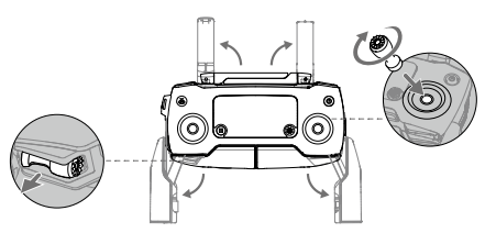
- Unfold the mobile device clamps and the antennas.
- Remove the control sticks from their storage slots on the remote controller and screw them into place.

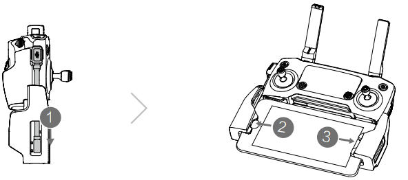
- Choose an appropriate RC cable based on the type of mobile device.
- Connect the end of the RC cable to your mobile device. Secure your mobile device by pushing both clamps inward.

- Refer to the figure below for how to replace the RC cable. The RC cable slider must be replaced if using a USB-C RC cable.
Flight Modes
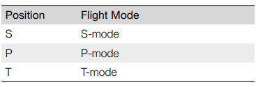
The Mavic 2 Pro/Zoom has three flight modes, plus a fourth flight mode that the aircraft switches to in certain circumstances:
P-mode (Positioning)
- P-mode works best when the GPS signal is strong.
- The aircraft utilizes GPS and the Vision Systems to locate itself, stabilize, and navigate between obstacles. Intelligent Flight Modes are enabled in this mode.
- When the Forward and Backward Vision Systems are enabled, and lighting conditions are sufficient, the maximum flight altitude angle is 25°, the maximum forward flight speed is 31 mph (50 kph), and the maximum backward flight speed is 27 mph (43 kph).
- P-mode requires larger stick movements to achieve high speeds.
- The aircraft automatically changes to Attitude (ATTI) mode when the Vision Systems are unavailable or disabled,d and when the GPS signal is weak or the compass experiences interference.
- When the Vision Systems are unavailable, the aircraft cannot position itself or brake automatically, which increases the risk of potential flight hazards. In ATTI mode, the aircraft may be more easily affected by its surroundings.
- Environmental factors such as wind can result in horizontal shifting, which may present hazards, especially when flying in confined spaces.
S-mode (Sport)
In S-mode, the Vision Systems are disabledd and the aircraft only uses GPS for positioning. The maximum flight speed is 44.7 mph (72kph). Intelligent Flight Modes are not available,ble and the aircraft cannot sense or avoid obstacles.
- In S-mode, aircraft responses are optimized for agility and speed, making it more responsive to stick movements.
T-mode (Tripod)
T-mode is based on P-mode, and the flight speed is limited, which makes the aircraft more stable during shooting. The maximum flight speed, ascent speed, and descent speed are 1 m/s. Intelligent Flight Modes are not available in T-mode.
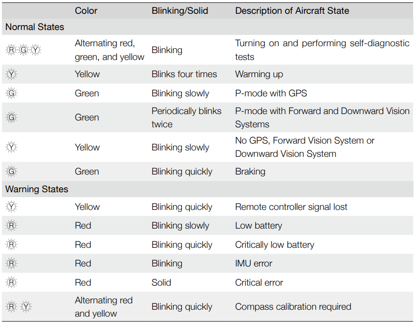
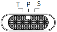
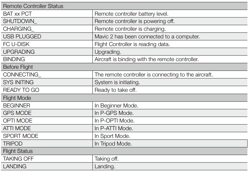
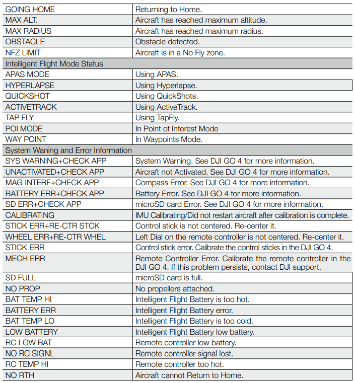
Aircraft LEDs and Status Indicator
The Mavic 2 Pro/Zoom has Front LEDs and Aircraft Status Indicators as shown in the figure below.
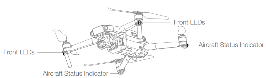
- The Front LEDs show the orientation of the aircraft and glow solid red when the aircraft is turned on to indicate the front of the aircraft (they can be turned off in the DJI GO 4).
- The Aircraft Status Indicators communicate the status of the aircraft’s flight control system. Refer to the table below for more information about the Aircraft Status Indicators. The Aircraft Status Indicators also flash when the Home Point is being recorded, as described in the Return to Home section.
Aircraft Status Indicator States
Return to Home
The Return to Home (RTH) function brings the aircraft back to the last recorded Home Point. There are three types of RTH: Smart RTH, Low Battery RTH, and Failsafe RTH. This section describes these three scenarios in detail.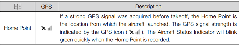
Smart RTH
If the GPS signal is sufficiently strong, Smart RTH can be used to bring the aircraft back to the Home Point. Smart RTH is initiated either by tapping in the DJI GO 4 or by pressing and holding the RTH button on the remote controller. Exit Smart RTH by tapping in the DJI GO 4 or by pressing the RTH button on the remote controller.
Low Battery RTH
- Low Battery RTH is triggered when the Intelligent Flight Battery is depleted to the point that the safe
return of the aircraft may be affected. Return home or land the aircraft immediately when prompted. DJI GO 4 displays a warning when the battery level is low. - The aircraft will automatically return to the Home Point if no action is taken after a ten-second countdown. The user can cancel RTH by pressing the RTH button or the Flight Pause button on the remote controller.
- If RTH is cancelled following a low battery level warning, the Intelligent Flight Battery may not have
enough charge for the aircraft to land safely, which may lead to the aircraft crashing or being lost. The
thresholds for the battery level warnings are automatically determined based on the aircraft’s current
altitude and distance from the Home Point. - The aircraft will land automatically if the current battery level can only support the aircraft long enough to descend from its current altitude. The user cannot cancel the auto landing, but can use the remote controller to alter the aircraft’s orientation during the landing process.
If a battery level warning appears, take action as described in the table below. RTH and Battery Level Warnings (when using firmware v00.06.00.00)
RTH and Battery Level Warnings (when using updated firmware v01.00.00.00)
Failsafe RTH
- The aircraft allowsitt to create a real-time map of its flight route as it flies. If the Home Point
was successfully recorded, and the compass is functioning normally. Failsafe RTH automatically activates after the remote control signal is lost for more than two seconds. When Failsafe RTH is activated, the aircraft starts to retrace its original flight route home. - If the remote control signal is re-established within 60 seconds of Failsafe RTH being activated, the aircraft hovers at its present location for 10 seconds and waits for pilot commands. The user may tap in the DJI GO 4 or press the RTH button on the remote controller to cancel Failsafe RTH and retake control. If no pilot command is given, the aircraft flies to the Home Point in a straight line.
- If the remote control signal is still lost 60 seconds after activating Failsafe RTH, the aircraft stops retracing its original flight route and flies to Home Point in a straight line.
RTH Procedure
Smart RTH, Low Battery RTH, and Failsafe RTH all follow the RTH procedure:
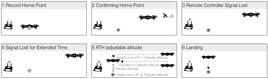
- The aircraft adjusts its orientation.
- If the aircraft is further than 20 m from the Home Point when the RTH procedure begins, it ascends to the pre-set RTH altitude and then flies to the Home Point at a speed of 12 m/s. If the current altitude is higher than the RTH altitude, the aircraft flies to the Home Point at the current altitude. Forward and Backward vision systems are enabled.
- If the aircraft is between 5 m and 20 m from the Home Point when the RTH procedure begins:
- If the RTH at Current Altitude option is enabled, the aircraft flies to the Home Point at the current altitude, unless the current altitude is less than 2 m, in which case the aircraft ascends to 2 m and then flies to the Home Point at a speed of 3 m/s.
- If the RTH at Current Altitude option is disabled, the aircraft lands immediately.
- If the aircraft is less than 5 m from the Home Point when the RTH procedure begins, it lands immediately.
- After reaching the Home Point, the aircraft lands and the motors stop.
Obstacle Avoidance during RTH
Provided that lighting conditions are sufficient for the Forward and Backward Vision Systems to operate, the Mavic 2 Pro/Zoom senses and actively attempts to avoid obstacles during RTH. The obstacle avoidance procedure is as follows:
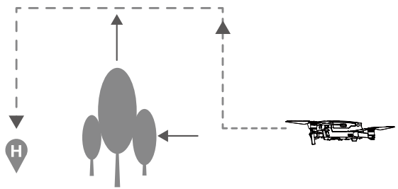
- The aircraft decelerates when an obstacle is sensed.
- The aircraft stops,d hovers, and then ascends until no obstacle is sensed.
- The RTH procedure resumes. The aircraft flies to the Home Point at the new altitude.
Landing Protection
Landing Protection activates during Smart RT, H, and the aircraft performs as follows:
- When Landing Protection determines that the ground is suitable for landing, the aircraft lands gently.
- If Landing Protection determines that the ground is not suitable for landing, the aircraft hovers and waits for the pilot to confirm it is suitable to land.
- If Landing Protection is not operational, DJI GO 4 displays a landing prompt when the aircraft descends below 0.5 m. Pull down on the throttle for one second or use the auto landing slider in the app to land.
- Landing Protection activates during Low Battery RTH and Failsafe RTH. The aircraft performs as follows:
- During Low Battery RTH and Failsafe RTH, the aircraft hovers at 2 m above the ground and waits for the pilot to confirm it is suitable to land.
- Pull down on the throttle for one second or use the auto landing slider in the app to land. Landing Protection activat, es and the aircraft performs the steps listed above.
Precision Landing
The Mavic 2 Pro/Zoom automatically scans and attempts to match the terrain features underneath during Return to Home. When the current terrain matches Home Point terrain, the Mavic 2 Pro/Zoom will start landing. The DJI GO 4 app will show a terrain feature mismatch prompt if matching fails. Precision Landing performance is subject to the following conditions:
- The Home Point must be recorded upon takeoff and must not be changed during flighse the aircraft will have no record of the Home Point’s terrain features.
- During takeoff, the aircraft must ascend vertically 7 m before moving horizontally.
- The Home Point terrain features must remain largely unchanged.
- The Home Point terrain features must be sufficiently distinctive.
- The lighting conditions must not be too light or too dark.
- The following actions are available during Precision Landing:
- Throttle down to accelerate landing.
- Move the control sticks in any other direction to stop Precision Landing.
- The Mavic 2 Pro/ Zoom will descend vertically after the control sticks are released.
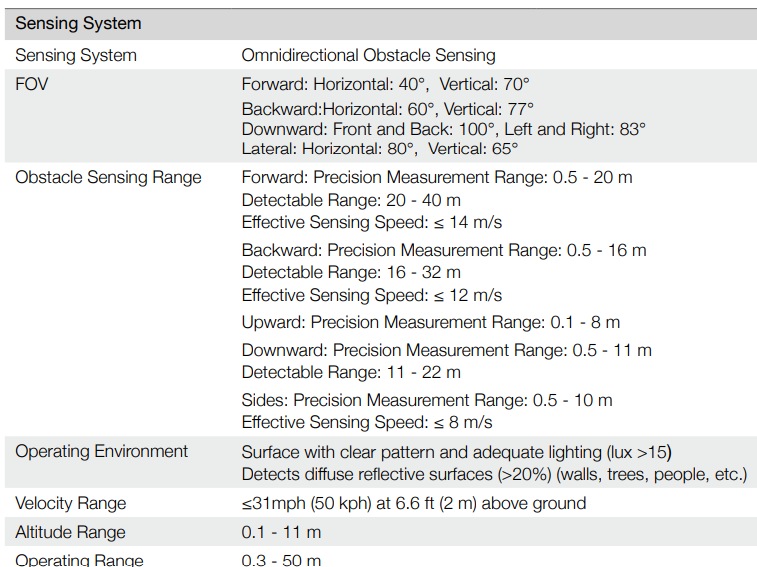
Vision Systems and Infrared Sensing Systems
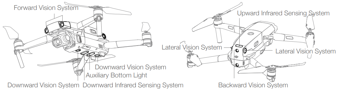
- The Mavic 2 Pro/Zoom is equipped with Forward, Backward, Downward, and Lateral Vision Systems, and Upward and Downward Infrared Sensing Systems, providing omnidirectional obstacle sensing (if lighting conditions are adequate).
- The main components of the Forward, Backward, and Downward Vision Systems are six cameras located on the nose, rear side, and the underside of the aircraft. Lateral Vision Systems are two cameras located on either side of the aircraft.
- The main components of the Upward and Downward Infrared Sensing Systems are two 3D infrared modules located on the upper and underside of the aircraft.
- The Downward Vision System and Infrared Sensing Systemhelps the aircraft maintain its current position and hover in place more precisely, and to fly indoors or in other environments where a GPS signal is unavailable. In addition, the Auxiliary Bottom Light located on the underside of the aircraft improves visibility for the Downward Vision System in weak light conditions.
Detection Range
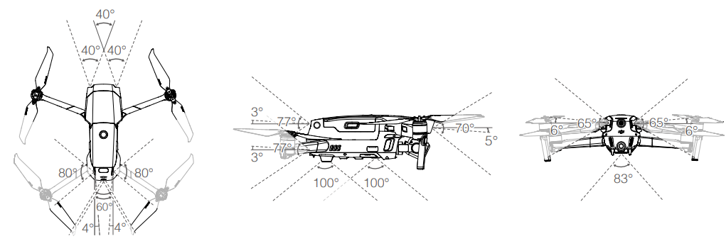
The detection range of the Vision Systems is depicted as follows. Please note that the aircraft cannot sense or avoid the obstacles that are not within detection range.
Calibrating Vision System Cameras
- The Vision System cameras installed on the aircraft are factory calibrated. If the aircraft experiences a collision, however, it may require calibration via DJI Assistant 2 for Mavic or DJI GO 4.
- The most accurate way to calibrate the Vision System cameras is by using DJI Assistant 2 for Mavic. Follow the steps below to calibrate the Forward Vision System cameras, then repeat the steps to calibrate other Vision System cameras.
When a vision system calibration is required, DJI GO 4 sends a notification. If a computer is not nearby,
however, a quick calibration can be performed in the app. Tap the Aircraft Status bar and Vision Sensors to start quick calibration.
Using the Vision Systems
The Downward Vision System and Infrared Sensing System activate automatically when the aircraft is turned on. No further action is required. When using the Downward Vision System, the aircraft can hover precisely, even without GPS.
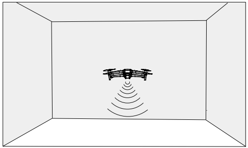
The Downward Vision System is typically used in indoor environments where GPS is unavailable. The Downward Vision System works best when the aircraft is at altitudes of 1.6 to 33 ft (0.5 to 11 m). Please note that the Vision Positioning function may be affected if the aircraft’s altitude is above 33ft (11 m).
Follow the steps below to use the Downward Vision System.
- Ensure the aircraft is in P-mode and place the aircraft on a flat surface. Please note that the Downward Vision System cannot work properly on surfaces without clear pattern variations.
- Turn on the aircraft. The aircraft hovers in place after takeoff. The Aircraft Status Indicators flash green twice, which indicates the Downward Vision System is working.
Using the Forward and Backward Vision Systems, the aircraft can actively brake when detecting obstacles in front. The Forward and Backward Vision Systems work best with adequate lighting and clearly marked or textured obstacles. To allow for sufficient time to break, the aircraft should not fly more than 31 mph (50 kph) when flying forward or more than 27 mph (42 kph) when flying backward. The Lateral Vision Systemsrequires better lighting and more textured or clearly marked obstacles, and cannot sense dynamic objects, such as moving people, vehicles, tree branches, or blinking lights. The Lateral Vision Systems are only available in some Intelligent Flight Modes and Tripod Mode. The angular speed is limited to 24° /s, and the lateral flight speed is limited to 18 mph (29 mph).
Intelligent Flight Modes
The Mavic 2 Pro/Zoom supports Intelligent Flight Modes including Hyperlapse, QuickShots, ActiveTrack 2.0, Point of Interest (POI 2.0), Waypoints, TapFly, and Cinematic Mode. Select an Intelligent Flight Mode in DJI GO 4. Ensure the battery level is sufficient, and the aircraft is working on P-mode when using the Intelligent Flight Modes.
Hyperlapse
Hyperlapse shooting modes include Free, Circle, Course Lock, and Waypoint.
Free
The aircraft automatically takes photos and generates a time-lapse video. Free mode can be used while
the aircraft is on the ground. After takeoff, control the aircraft’s altitude, flight speed, and gimbal angle
using the remote controller. Hold the control sticks and accelerate at a steady speed for two seconds,
and then press the C1 button. Follow the steps below to use Free:
- Set the interval time and video duration. The screen displays the number of photos that will be taken
and how long the shooting time will be. - Tap the shutter button to begin.
Circle
The aircraft automatically takes photos while flying around the selected subject to generate a time-lapse video. Follow the steps below to use Circle:
- Set the interval time and video duration.
- Select a subject on the screen.
- Tap the shutter button to begin.
Course Lock
Follow the steps below to use Course Lock:
- Set the interval time and video duration.
- Set a flight direction.
- Select a subject (if applicable).
- Tap the shutter button to begin.
Waypoints
The aircraft automatically takes photos on a flight path of two to five waypoints and generates atime-lapsee video. The aircraft can fly in order from Waypoint No. 1 to No. 5 or from No. 5 to No. 1. Please note that the aircraft exits from Waypoints if any command from the remote controller is received. Follow the steps below to use Waypoints.
- Set the desired waypoints and the lens direction.
- Set the interval time and video duration. The screen displays the number of photos that will be taken and how long the shooting time will be.
- Tap the shutter button to begin.
The aircraft will generate a timelapse video with a resolution of 1080p25 automatically, which is viewable in the Playback menu. You can select to save the JPEG or RAW format footage and to store the footage in the built-in storage or an SD card in the camera settings.
Task Library
Use the Task Library to easily record flight paths, which can be repeated later.
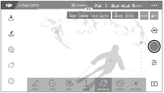
QuickShots
QuickShots shooting modes include Dronie, Circle, Helix, Rocket, Boomerang, Asteroid, and Dolly Zoom (only available with Mavic 2 Zoom). The Mavic 2 Pro/Zoom records a video according to the selected shooting mode and then automatically generates a 10-second video. The video can then be viewed, edited, or shared to social media from Playback.
- Dronie: The aircraft flies backward and ascends, with the camera locked on the subject.
- Circle: The aircraft circles around the subject.
- Helix: The aircraft ascends and spirals around the subject.
- Rocket: The aircraft ascends with the camera pointing downward.
- Boomerang: The aircraft flies around the subject in an oval path, ascending as it flies away from
its starting point and descending as it flies back. - Asteroid: The aircraft flies backward and upward, takes several photos, and then flies back to the starting point. The video starts with a panorama of the highest position and then shows the descent.
- Dolly Zoom: The Mavic 2 Zoom flies backward and upward. It adjusts the zoom during flight to keep the selected subject the same while the background changes.
Using QuickShots
Ensure that the aircraft is in P-mode and that the Intelligent Flight Battery is sufficiently charged. Follow the steps below to use QuickShots.
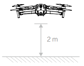
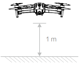
- Take off and hover at least 6.6 ft (2 m) above the ground.

- In DJI GO 4, tap, then select QuickShots and follow the prompts.

- Select your target subject in Camera View (tap the circle on the subject or drag a box around the subject) and choose a shooting mode. Tap “GO” to begin recording. The aircraft flies back to its original position once shooting is finished.
- Tap to access the video.
Exiting
Toggle the Flight Mode switch to S-mode or T-mode to exit QuickShots anytime during shooting (when Multiple Flight Modes is enabled in DJI GO 4). Press the Flight Pause button on the remote controller or tap in DJI GO 4 or for the emergency brake.
ActiveTrack 2.0
ActiveTrack 2.0 allows you to select an object on your mobile device screen. The aircraft adjusts its flight to track the subject. No external tracking device is required. Mavic 2 Pro/Zoom can automatically identify up to 16 objects and uses different tracking strategies to track people, vehicles, and boats.
Using ActiveTrack 2.0
Ensure that the aircraft is in P-mode and that the Intelligent Flight Battery is sufficiently charged. Follow the steps below to use ActiveTrack 2.0
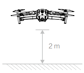
- Take off and hover at least 6.6 ft (2 m) above the ground.

- In DJI GO 4, tap, then select ActiveTrack 2.0.

- For optimal performance, it is recommended to select a subject that is automatically recognized by the aircraft.
- The aircraft automatically avoids obstacles in its flight path. If the aircraft loses track of the subject because it is moving too fast or is obscured, re-select the subject to resume tracking.
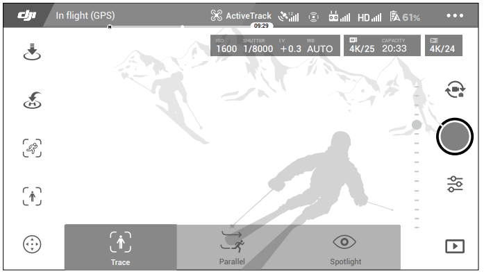
ActiveTrack 2.0 includes the following sub-modes
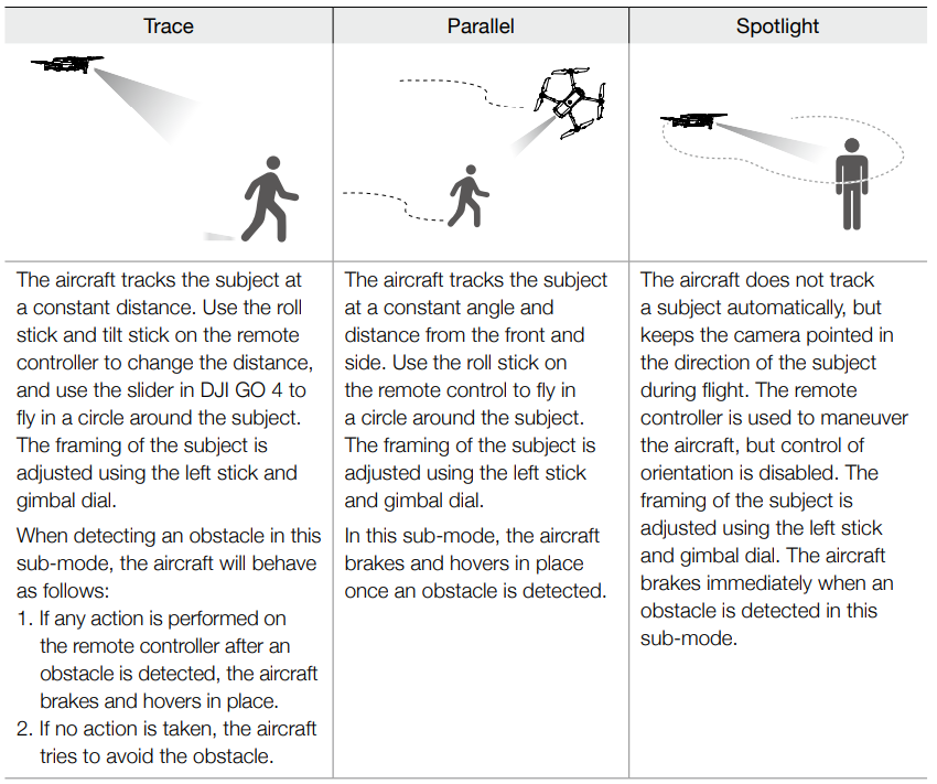
Exiting ActiveTrack 2.0
Press the Flight Pause button on the remote controller to brake immediately. Tap on the screen or toggle the Flight Mode switch to S-mode on the remote controller to exit ActiveTrack 2.0. After exiting ActiveTrack 2.0, the aircraft hovers in place, at which point you may choose to fly manually, track another subject, or return home.
Point of Interest 2.0 (POI 2.0)
Select a static subject as the Point of Interest. Set the circle radius, flight altitude, and flight speed. The aircraft flies around the subject according to these settings. Mavic 2 Pro/Zoom supports selecting the POI through GPS positioning and selecting on the screen.
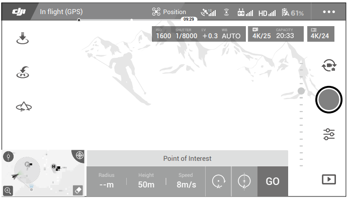
- Select POI on the screen: drag a box around the desired subject and tap the “GO” icon on the screen. The aircraft starts to measure the location of the subject and flies around the subject once it measures the location successfully. Use the gimbal dial to adjust the subject framing. The circle radius, flight altitude, and flight speed can also be adjusted during flight.
- Select a subject through GPS positioning: Manually fly the aircraft above the subject, and then press the C1 button or select in DJI GO 4 to confirm the subject. Fly the aircraft at least 5 m away from the Point of Interest. The flight speed and the circle direction can be set in DJI GO 4. Tap “GO” to start flying. Use the gimbal dial to adjust the subject framing. The circle radius, flight altitude, and flight speed can also be adjusted during flight.
Flight Parameter Settings
- Flight Speed: Flight speed range is 0-10 m/s; the “+” value means the aircraft circles the point counter-clockwise, and the “–” value means the aircraft circles the point clockwise. Adjust the speed by sliding the onscreen slider, and use the roll stick on the remote controller to increase the value.
- Circle Radius: Adjust the radius by sliding the onscreen slider, and use the tilt stick on the remote controller to increase the value.
- Circle Attitude: Adjust the attitude by sliding the onscreen slider, and use the throttle stick on the remote controller to increase the value.
- Gimbal Angle: Use the yaw stick to control the gimbal’s yaw, and use the gimbal dial to control the gimbal’s tilt. Tap the icon to recenter the gimbal (If GPS Positioning is used to select the Point of Interest, only the yaw re-centers. If the Point of Interest is selected on the screen, both the yaw and tilt recenter).
- Circle Direction: Select the direction by sliding the onscreen button.
Exiting Point of Interest
Tap on the screen or press the Flight Pause button to pause the Point of Interest mode. Press and hold the Flight Pause button to exit Point of Interest mode.
Waypoints
The aircraft flies to the waypoints in order according to the settings. The flight orientation and speed can be controlled during flight. You can select the waypoints by flying the Mavic 2 Pro/Zoom to the waypoints and record them individually. The waypoints can also be selected and edited in the map before takeoff:
- Add waypoints and points of interest in the map. The aircraft’s camera points to the point of interest when traveling through the waypoints.
- Tap on the waypoints and points of Interest to set the altitude, flight speed, and other parameters.
- Drag the waypoints and points of Interest to adjust the positions.
- Flight speed, failsafe settings, and aircraft behavior can be configured after completing the waypoints.
- Waypoints and point of interest information can be saved in the app manually while editing in the map,p and the flight path can be recorded and repeated.
TapFly
TapFly features three sub-modes: Forward, Backward, and Free. Providing that lighting conditions are suitable, the aircraft automatically avoids obstacles it senses.
- Forward: The aircraft flies towards the target with the Forward Vision System sensing obstacles.
- Backward: The aircraft flies in the opposite direction of the target with the Backward Vision System sensing obstacles.
- Free: The aircraft flies towards the target. The remote controller can be used to maneuver the orientation of the aircraft freely. The aircraft cannot avoid obstacles in this mode. Fly with caution.
Using TapFly
Ensure that the aircraft is in P-mode and that the Intelligent Flight Battery is sufficiently charged. Follow the steps below to use TapFly.
- Take off and hover at least 3.3 ft (1 m) above the ground.

- In DJI GO 4, ta, select TapFly, then select a sub-mode and follow the prompts.

- Tap on the target and wait for “GO” to appear. Tap “GO” to confirm the selection, and the aircraft flies to the target automatically. A prompt appears if the target cannot be reached. If this is the case, select another target and try again. The target can be changed mid-flight by tapping the screen.
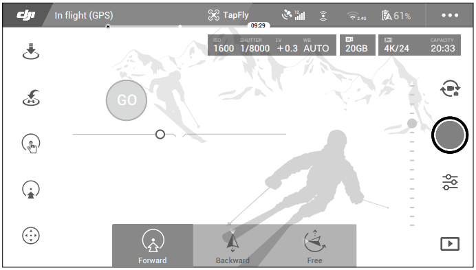
Exiting TapFly
Press the Flight Pause button on the remote controller or pull a control stick in the direction opposite to the direction of flight, and the aircraft brakes and hovers in place. Tap the screen to resume TapFly. Tap or toggle the Flight Mode switch to S-mode to exit TapFly.
Cinematic Mode
Tap in DJI GO 4 to select Cinematic mode. In Cinematic mode, the aircraft’s braking distance is extended, and its rotation speed is reduced. The aircraft slows down gently until it stops, keeping footage smooth and stable even if control inputs are choppy.
Advanced Pilot Assistance Systems
- The Advanced Pilot Assistance Systems (APAS) feature is available in P-mode. When APAS is enabled, the aircraft continues to respond to user commands and plans its path according to both control stick inputs and the flight environment. APAS makes it easier to avoid obstacles, obtain smoother footage, and gives a better flying experience.
- When APAS is enabled, pressing the Flight Pause button on the remote controller or tapping in DJI GO 4 brings the aircraft to a stop. The aircraft hovers for three seconds and awaits pilot commands. To enable APAS, tap APAS in DJI GO 4.
Flight Recorder
Flight data, including flight telemetry, aircraft status information, and other parameters are automatically saved to the aircraft’s internal data recorder. The data can be accessed using DJI Assistant 2 for Mavic.
Attaching and Detaching the Propellers
The Mavic 2 Pro/Zoom uses low-noise propellers. There are two varieties of the propellers, which are
designed to spin in different directions. White marks are used to indicate which propellers should be attached to which motors.
Attaching the Propellers
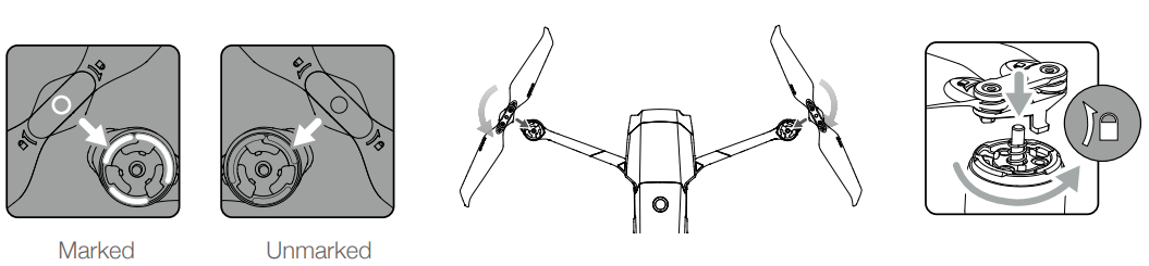
Attach the propellers with the white marks to the motors with white marks and the unmarked propellers to the motors without marks. Press each propeller down onto the motor and turn until it is secure.
Detaching the Propellers
Press the propellers down onto the motors and rotate them in the unlock direction.
Intelligent Flight Battery
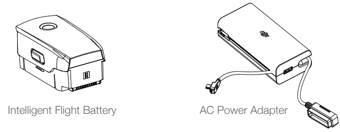
The Mavic 2 Intelligent Flight Battery is a 15.4 V, 3850 mAh battery with smart charging/discharging functionality. Only use a DJI-approved AC power adapter to charge the battery.
Battery Features
- Battery Level Display: The LED indicators display the current battery level.
- Auto-Discharging Function: To prevent swelling, the battery automatically discharges to less than 70% of the maximum battery level when it is idle for more than 10 days. It takes approximately three to four days to discharge the battery to 60%. It is normal to feel moderate heat being emitted from the battery during the discharging process.
- Balanced Charging: During charging, the voltages of the battery cells are automatically balanced.
- Overcharge Protection: The battery stops charging automatically once fully charged.
- Temperature Detection: The battery only charges when the temperature is between 41° and 104° F (5° and 40° C).
- Overcurrent Protection: The battery stops charging if an excess current is detected.
- Over-discharge Protection: Discharging stops automatically to prevent excess discharge.
- Short Circuit Protection: The power supply is automatically cut off if a short circuit is detected.
- Battery Cell Damage Protection: DJI GO 4 displays a warning message when a damaged battery cell is detected.
- Hibernation Mode: The battery switches off after 20 minutes of inactivity to save power. If the battery level is less than 10%, the battery enters Hibernation mode to prevent over-discharge. In Hibernation mode, the battery level indicators do not illuminate. Charge the battery to wake it from hibernation.
- Communication: Information about the battery’s voltage, capacity, and current is transmitted to the aircraft.
Using the Battery
Checking Battery Level
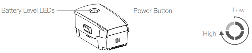
The battery level LEDs display how much charge remains.
Powering On/Off
Press the Power button once, then press again and hold for two seconds to turn the battery on or off.
Low Temperature Notice
- Ensure to fully charge the battery before takeoff.
- When in low-temperature environments, end the flight as soon as DJI GO 4 displays the low battery level warning.
- To ensure optimal performance of the battery, keep the battery temperature above 68° F (20° C).
- The reduced battery capacity in low-temperature environments reduces the aircraft’s wind speed resistance performance. Please fly with caution.
- Fly with extra caution at a high sea level.
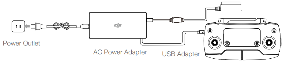
Charging the Battery
Fully charge the Intelligent Flight Battery before using it for the first time.
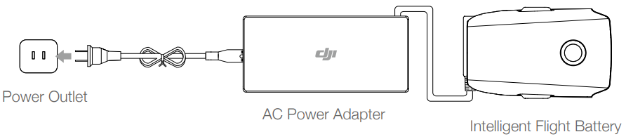
- Connect the AC power adapter to a power source (100-240 V, 50/60 Hz).
- Attach the Intelligent Flight Battery to the AC power adapter using the battery charging cable with the battery powered off.
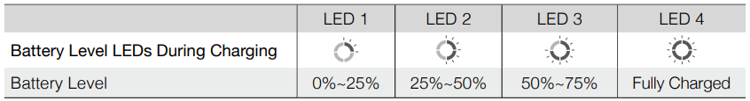
- The battery level LEDs display the current battery level during charging.
- The Intelligent Flight Battery is fully charged when the battery level LEDs are all turned off. Detach the AC power adapter when the battery is fully charged.
- Charging Time: 1 hour and 30 minutes.
Battery Level LEDs During Charging
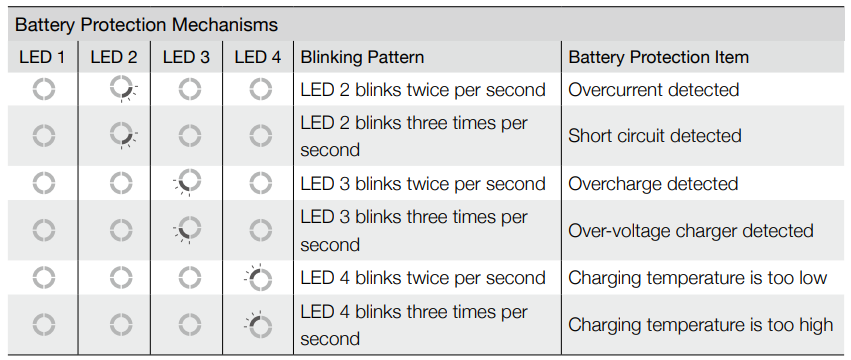
Battery Protection
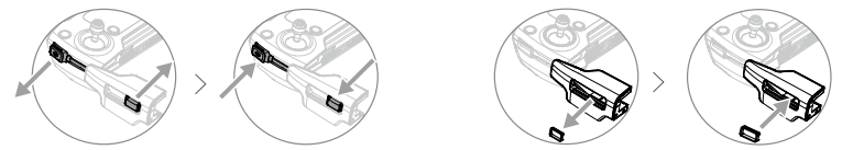
Inserting the Intelligent Flight Battery
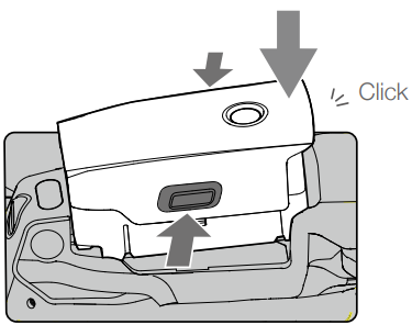
Insert the Intelligent Flight Battery into the aircraft’s battery compartment.
Removing the Intelligent Flight Battery
Slide the battery latches on the sides of the Intelligent Flight Battery to open the battery compartment.
Gimbal
- The Mavic 2 Pro/Zoom 3-axis gimbal provides stabilization for the camera, allowing you to capture clear and stable images and video. The gimbal has a tilt range of -90˚ to +30˚.
- Use the gimbal dial on the remote controller to control the camera’s tilt. Alternatively, enter Camera View in DJI GO 4. Press the screen until a blue circle appears and drag the circle up and down to control camera tilt. Dragging the circle left and right controls the aircraft’s orientation.
Gimbal Operation Modes
Two gimbal operation modes are available. Switch between the different operation modes on the camera settings page of DJI GO 4.
- Follow Mode: The angle between the gimbal’s orientation and the aircraft’s nose remains constant at all times.
- FPV Mode: The gimbal synchronizes with the movement of the aircraft to provide a first-person perspective flying experience.
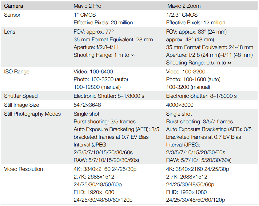
Camera
- The Mavic 2 Pro uses a 1″ CMOS sensor camera (jointly developed by DJI and Hasselblad), which features a lens with an adjustable aperture with a range of F2.8-F11. The camera supports auto focus, which can focus from 1 m to infinity.
- The Mavic 2 Pro camera shoots up to 4K30fps video and 20 MP photos, supports shooting modes such as Single shot, Burst shooting, Interval, Panorama, Slow motion, and Enhanced HDR.
- The Mavic 2 Zoom uses a 1/2.3″ CMOS sensor camera, supports 2x optical zoom, and the lens is 24-48 mm (35 mm format equivalent). The camera supports auto focus, which can focus at 0.5 m to infinity.
- The camera also supports replacing filters. The Mavic 2 Zoom camera shoots up to 4K30fps video and 12-megapixel photos, supports shooting modes such as Single shot, Burst shooting, Interval, Panorama, Slow motion, and Enhanced HDR. Mavic 2 Zoom supports 2x optical zoom and 2x digital zoom when recording video in 1080p24/25/30.
Storing the Photos and Videos
The Mavic 2 Pro/Zoom comes with 8 GB of internal storage and also supports the use of a microSD card to store your photos and videos.
Video Edit
- The Mavic 2 Pro supports video formats MP4 and MOV, providing Normal, D-Log, and HLG color modes.
- For the Mavic 2 Pro, Full FOV down samples from the 5.5K sensor to 4K resolution while HW crops in the center for finer image quality but less FOV. Full FOV view is 75° and HQ view is 55°. You can select between them according to your actual shooting demands.
- Mavic 2 Zoom supports video formats MP4 and MOV, providing Normal and D-Cinelike color modes.
Video Distortion Correction
- The Mavic 2 Pro and Mavic 2 Zoom shoot 8-bit videos while automatically correcting the video distortion commonly found in the medium. Only the Mavic 2 Pro, however, can shoot 10-bit videos. 10-bit videos are smoother than 8-bit videos, which is advantageous for post-production color modulation. Please note that automatic video distortion correction is unavailable for 10-bit videos on the Mavic 2 Pro.
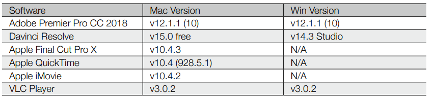
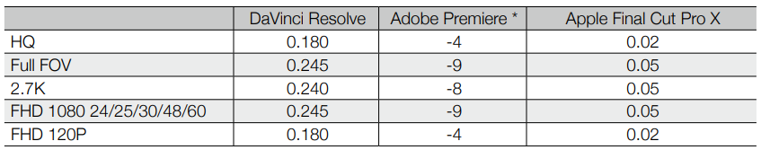
- There are several software programs available to correct video distortion, such as DaVinci Resolve, Adobe Premiere, and Apple Final Cut Pro X. Videos with different resolutions have different types of distortion. The table below lists the recommended values to correct distortion when using different software. Please note that by correcting the distortion, the overall quality of the video will diminish.
Remote Controller
- Built into the remote controller is DJI’s long-range transmission technology, OcuSync 2.0, offering a
maximum transmission range of 5 mi (8 km) and displaying video from the aircraft to DJI GO 4 on your
mobile device at up to 1080p. Easily control the aircraft and camera using the onboard buttons. - The remote controller works at both 2.4 GHz and 5.8 GHz, automatically selecting the best transmission channel. OcuSync 2.0 reduces the latency to 120-130 ms by improving the camera performance through the video decoding algorithm and the wireless link.
- The built-in battery has a capacity of 3950 mAh and a maximum run time of 2 hours and 15 minutes. The remote controller charges the mobile device with a charging ability of 500 mA@5V.
Using the Remote Controller
Press the Power button to display the current battery level on the LCD screen. Press once, then again, and hold to turn the remote controller on or off.
Charging the Battery
Connect the provided AC power adapter to the power port on the remote controller. It takes approximately 2 hours and 15 minutes to charge the remote controller battery fully. Remove the RC cable from the remote controller before charging.
Controlling the Camera
Use the Aperture/Shutter Adjustment Dial to adjust the aperture and shutter parameters (Mavic 2 Pro only).
- Use the Record button to start/stop recording.
- Use the Focus/Shutter button to auto focus and take photos.
- Use the Zoom Adjustment Dial to zoom in/out (Mavic 2 Zoom only)
Controlling the Aircraft
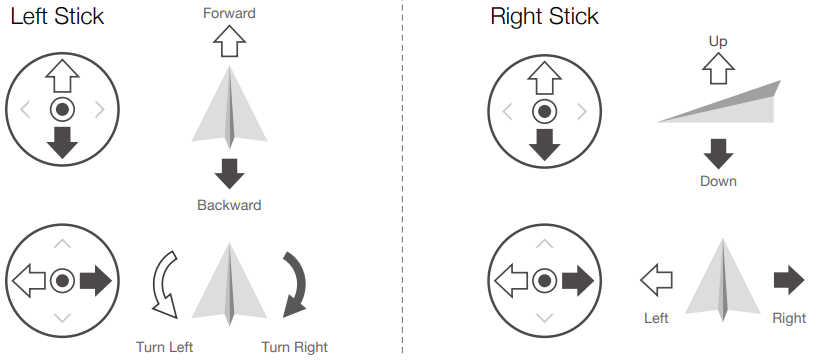
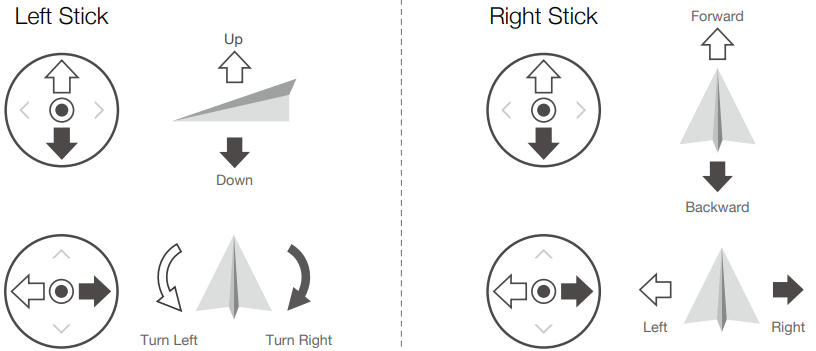
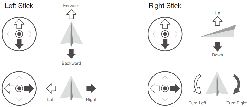
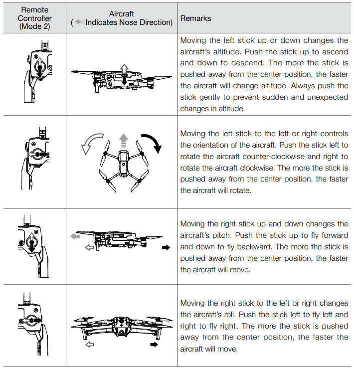
The control sticks control the aircraft’s orientation (yaw), forward/ backward movement (pitch), and altitude. (throttle), and left/right movement (roll). The control stick mode determines the function of each control stick movement. Pushing a control stick away from the center position performs the functions shown in the figure below.
Modes
Flight Mode Switch
Toggle the switch to select the desired flight mode.
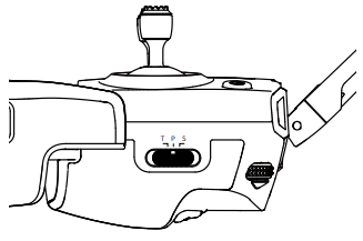
Regardless of which position the switch is in on the remote controller, the Mavic 2 Pro/Zoom begins in P-mode by default. To switch flight modes, first go to Camera View in DJI GO 4, tap, and enable “Multiple Flight Modes. After enabling multiple flight modes, toggle the switch to P and then to S or T to switch flight modes.
RTH Button
Press and hold the RTH button to start the Return to Home (RTH) procedure, where the aircraft returns to the last recorded Home Point. Press this button again to cancel RTH and regain control of the aircraft. Refer to the Return to Home section for more information about RTH.
C1 and C2 Button
The default configuration for the C1 button is Center Focus, and the default configuration for the C2 button is Playback.
Remote Controller Alert
The remote controller sounds an alert during RTH or when the battery level is low (6% to 15%).
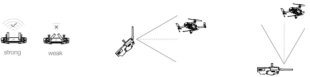
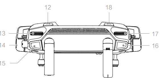
Ensure that the aircraft is flying within the optimal transmission zone. To maintain optimal transmission performance, adjust the remote controller and antennas according to the figure above.
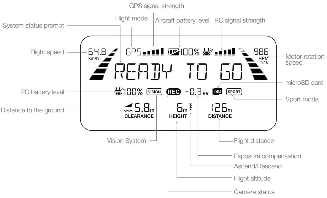
LCD Screen
The LCD Screen displays various system statuses, including real-time flight telemetry and battery levels. Refer to the figure below for the meaning of each icon on the LCD Screen.
Dual Remote Controller Mode
The Mavic 2 Pro/Zoom supports Dual Remote Controller Mode, which allows two remote controllers to connect to the same aircraft. 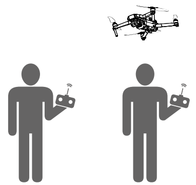 Both the Primary remote controller and the Secondary remote controller can control the orientation of the aircraft and the movement of the gimbal and camera operation. Please note the different operations of the Primary and Secondary remote controllers listed below.
Gimbal Dial
Both the Primary remote controller and the Secondary remote controller can control the gimbal dial, but the Primary remote controller has priority. For example, the Secondary remote controller is unable to control the gimbal dial when the Primary remote controller is using the gimbal dial. After the Primary remote controller has stopped controlling the gimbal dial for two seconds or more, the Secondary remote controller can control the gimbal dial.
Control Stick
Both the Primary remote controller and the Secondary remote controller can control the orientation of the aircraft using control sticks. The Primary remote controller has priority. The Secondary remote controller is unable to control the aircraft’s orientation when the Primary remote controller is operating the control sticks.
After the control sticks are idle for two seconds or more, the Secondary remote controller can control the aircraft’s orientation.
DJI GO 4 Settings
The display and parameter settings for the Primary and Secondary remote controllers in DJI GO 4 are the same. The Secondary remote controller can only configure the flight controller, vision system, video transmission, and Intelligent Flight Battery. Display and parameter settings for the Primary and Secondary remote controllers are the same in DJI GO 4.
Linking the Remote Controller
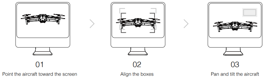
Follow these steps to link a new remote controller.
- Power on the aircraft and the remote controller.
- Launch DJI GO 4.
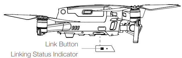
- Enter “Camera” and tap on and then tap the button to confirm. The remote controller is ready to link.
- Locate the link button on the side of the aircraft, as shown in the figure below. Press the link button to start linking. The Linking Status Indicator displays solid green once the remote controller successfully links to the aircraft, and the LCD screen on the remote controller displays the aircraft’s information.
DJI GO 4 App
Use this app to control the gimbal, camera, and other aircraft functions.
Function Menu
Tap in the top right corner of the screen to open the Function menu. The menu has five options:
- Scan QR Code: Scan a QR code to connect to an aircraft.
- Academy: Use the flight simulator, watch tutorials, and read the product manuals.
- Flight Records: Access all your flight records.
- GEO Zones: Read information about GEO Zones.
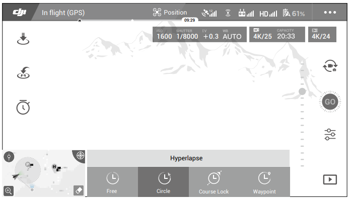
Camera View
Enter Camera View on the Equipment screen with your mobile device connected to the aircraft.
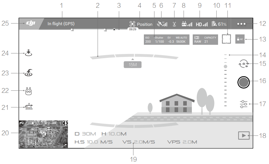
- System Status Bar: In flight (GPS): This icon indicates aircraft flight status and displays various warning messages.
- Obstacle Detection Status: Red bars display when obstacles are close to the aircraft. Orange bars display when obstacles are in the detection range.
- Battery Level Indicator Bar: The battery level indicator provides a dynamic display of the battery level.
- Flight Mode: The text next to this icon indicates the current flight mode.
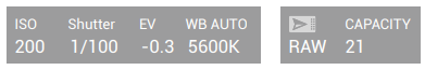
- Camera Parameters: Displays camera parameters, the capacity of the internal storage, and the microSD card.

- GPS Signal Strength: Shows the current GPS signal strength.
- Vision Systems Status: The green icon indicates the corresponding vision system is available.
- Remote Controller Signal: This icon shows the strength of the remote controller signal.
- HD Video Link Signal Strength: This icon shows the strength of the HD video downlink connection between the aircraft and the remote controller.
- Battery Settings: 61%: Shows the current battery level.
- Focus/Metering Button: Tap to switch between focus and metering mode.
- General Settings: Tap to enter the General Settings menu to set units of measurement, enable/disable livestream, and adjust flight route display settings.
- Auto Exposure Lock: AE: Tap to lock the exposure value.
- Gimbal Slider: Displays the gimbal tilt angle.
- Photo/Video Toggle: Tap to switch between photo and video recording modes.
- Shoot/Record Button: Tap to start shooting photos or recording video.
- Camera Settings: Tap to enter the Camera Settings menu.
- Flight Telemetry
- D 30M: Distance between the aircraft and the Home Point.
- H 10.0M: Height from the Home Point.
- HS 10.0M/S: Aircraft horizontal speed.
- VS 2.0M/S: Aircraft vertical speed.
- Map: Tap to view the map.

- Advanced Pilot Assistance Systems APAS: Tap to enable/disable the APAS feature.
- Intelligent Flight Modes: Tap to select Intelligent Flight Modes.
- Smart RTH: Tap to initiate Smart RTH and have the aircraft return to the last recorded Home Point.
- Auto Takeoff/Landing: Tap to initiate auto takeoff or landing.
- Back: Tap to return to the main menu.
Editor
After recording several video clips and downloading them to your mobile device, go to Editor on the home screen.
SkyPixel
- View and share the photos and videos on the SkyPixel page.
Me
- If you already have a DJI account, you will be able to participate in forum discussions and share your creation with the community.
Flight
Refer to the Remote Controller and DJI GO 4 sections for information about using the remote controller and the app to control the aircraft.
Flight Environment Requirements
- Do not use the aircraft in severe weather conditions, including wind speeds exceeding 10 m/s, snow, rain, and fog.
- Fly in open areas. Tall structures and large metal structures may affect the accuracy of the onboard compass and GPS.
- Avoid obstacles, crowds, high voltage power lines, trees, and bodies of water.
- Minimize interference by avoiding areas with high levels of electromagnetism, such as locations near power lines, base stations, electrical substations, and broadcasting towers.
- Aircraft and battery performance are subject to environmental factors such as air density and temperature.
- The Mavic 2 cannot use GPS within the polar regions. Use the Downward Vision System when flying in such locations.
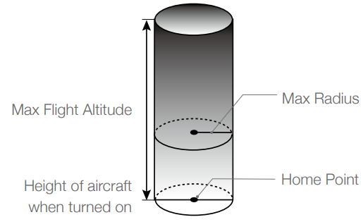
Flight Limits and GEO Zones
Abide by all laws and regulations when flying your Mavic 2 Pro/Zoom. Flight limitations include altitude limits, distance limits, and GEO Zones. Altitude limits, distance limits, and GEO Zones function concurrently to manage flight safety when operating in P-mode.
Flight Altitude and Distance Limits
The maximum flight altitude setting cannot exceed 1640 ft (500 m). Based on these settings, the aircraft will fly in a restricted cylinder, as shown below:

 GEO Zones
Pre-Flight Checklist
- Ensure the gimbal and camera are functioning normally.
- Ensure that nothing is obstructing the motors and that they are functioning normally.
- Ensure that the camera lens and Vision System sensors are clean.
- Use only genuine DJI parts or parts certified by DJI. Unauthorized parts or parts from non-DJI-certified manufacturers may cause system malfunctions and compromise safety.
Auto Takeoff
- Launch DJI GO 4 and tap “GO FLY” to enter Camera View.
- Complete all steps in the pre-flight checklist.
- Tap. If conditions are safe for takeoff, slide the slider to confirm.
- The aircraft will take off and hover 3.9 ft (1.2 m) above the ground.
Auto Landing
Only use auto landing if the Aircraft Status Indicator is blinking green. Follow the steps below to use the auto landing feature:
Tap. If conditions are safe to land, slide the slider to confirm. The aircraft will commence the auto-landing procedure. Warnings will appear in DJI GO 4 if the aircraft detects that conditions are not suitable for landing. Be sure to respond promptly.
Starting the Motors
Push both sticks to the inner or outer bottom corners to start the motors. Once the motors have started spinning, release both sticks simultaneously.
Stopping the Motors
There are two methods to stop the motors.
- Method 1: When the aircraft has landed, push and hold the left stick down.
- Method 2: The motors stop immediately. Release both sticks once the motors have stopped.
Stopping Motors Mid-Flight
Stopping the motors mid-flight will cause the aircraft to crash.
Test Flight
Takeoff/Landing Procedures
- Place the aircraft in an open, flat area with the Aircraft Status Indicator facing towards you.
- Turn on the aircraft and the remote controller.
- Launch DJI GO 4 and enter Camera View.
- Gently push the throttle stick to take off or use auto-takeoff.
- Pull the throttle stick or use auto-landing to land the aircraft.
- Turn off the aircraft and remote controller.
Video Suggestions and Tips
- Go through the full pre-flight checklist before each flight.
- Select the desired gimbal operation mode in DJI GO 4.
- Only shoot video when flying in P-mode or T-mode.
- DO NOT fly in bad weather conditions,s such as when it is raining or windy.
- Choose the camera settings that best suit your needs.
- Settings include photo format and exposure compensation.
- Perform flight tests to establish flight routes and to preview scenes.
- Push the control sticks gently to keep thaircraft’sft movement smooth and stable.
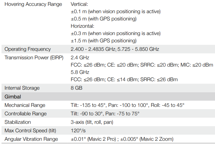
Specifications
Calibration Procedure
Choose an open area to carry out the following procedure.
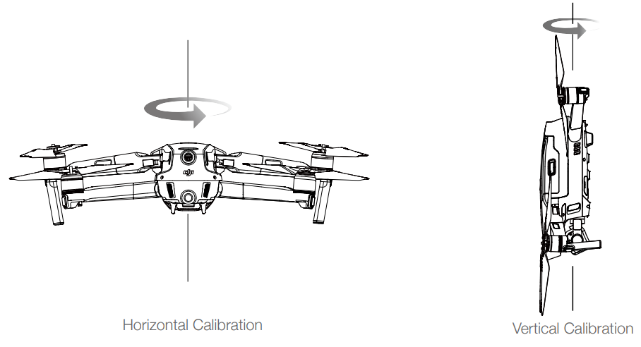
- Tap the System Status Bar in DJI GO 4, select “Calibrate”, and follow the on-screen instructions.
- Hold the aircraft horizontally and rotate it 360 degrees.
- The Aircraft Status Indicator will turn solid green.
- If the Aircraft Status Indicator blinks red, the calibration has failed.
- Change your location and try the calibration procedure again.
- Hold the aircraft vertically, with its nose pointing downward, and rotate it 360 degrees around a vertical axis.
Firmware Updates
Use DJI GO 4 or DJI Assistant 2 for Mavic to update the aircraft firmware.
Using DJI GO 4
When you connect the aircraft or remote controller to DJI GO 4, you will be notified if a new firmware update is available. To start updating, connect your mobile device to the internet and follow the onscreen instructions.
Using DJI Assistant 2 for Mavic
Follow the instructions below to update the firmware through DJI Assistant 2 for Mavic:
- USB cable.
- Power on the aircraft.
- Launch DJI Assistant 2 for Mavic and log in with your DJI account.
- Select “Mavic 2” and click on Firmware Updates on the left panel.
- Select the firmware version that you wish to update to.
- Wait for the firmware to download. The firmware update will start automatically.
- Reboot the aircraft after the firmware update is complete.
Remote Controller LCD Screen Menu
Firmware Update
Use DJI Fly or DJI Assistant 2 (Consumer Drones Series) to update the aircraft and the remote controller firmware.
Using DJI Fly
When connecting the aircraft or remote controller to DJI Fly, you will be notified if a new firmware update is available. To start updating, connect your remote controller or mobile device to the internet and follow the on-screen instructions.
Update the aircraft firmware.
- Select DJI Mini 3 and click Firmware Updates.
- Select the firmware version.
- Wait for the firmware to download. The firmware update will start automatically.
- Wait for the firmware update to complete.
Update the remote controller firmware.e
- Launch DJI Assistant 2 (Consumer Drones Series) on your computer and log in with your DJI account.
- Power on the remote controller and connect it to the computer via the USB-C port.
- Select the corresponding remote controller and click Firmware Updates.
- Select the firmware version.
- Wait for the firmware to download. The firmware update will start automatically.
- Wait for the firmware update to complete.
Customer Service
- Ph: +1 818 235 0789.
- Website: https://fly-safe.dji.com/nfz/nfz-query.
- Address: Lobby of T2, DJI Sky City, No. 53 Xianyuan Road, Xili Community, Xili Street, Nanshan District, Shenzhen, China, 518055.
DJI is a trademark of DJI. Copyright © 2025 DJI All Rights Reserved.